Why Are Drones Taking the Agri Insurance Industry to New Heights?

2019-05-23 13 min
This website uses cookies
We use Cookies to ensure better performance, recognize your repeat visits and preferences, as well as to measure the effectiveness of campaigns and analyze traffic. For these reasons, we may share your site usage data with our analytics partners. Please, view our Cookie Policy to learn more about Cookies. By clicking «Allow all cookies», you consent to the use of ALL Cookies unless you disable them at any time.
Aerial scouting in a cloud platform allows insurance companies and their customers to benefit from a higher degree of accuracy, a fast claims process, a lower chance of fraudulent claims, and a reduction in the cost of collateral damage assessment.
In this article, we look at the key challenges faced by agri insurers and how Skyglyph identified an exciting opportunity to help insurance companies use drones for simple and efficient aerial assessments. The many benefits of utilizing drone technology, and share how we delivered a web-based platform for Skyglyph that helps to streamline the claims process and benefit both insurers and farmers alike.
Burdened by legacy systems, governance, and statutory requirements, and outdated business models, it’s little wonder why many insurers have struggled to embrace new technologies in recent years. And yet, for those with the foresight to have put digital transformation front and center, they now stand to reap the rewards and leapfrog their competitors.
How? In the age of the Internet of Things (IoT), savvy digital insurers have started using connected devices to overcome key industry challenges. Take the agriculture insurance industry, for example, and crop insurance in particular.
Currently, the process involved in crop insurance and claims is a costly and time-consuming one. Other crucial challenges include:
A lack of data for product structuring and pricing;
Selective underwriting;
No monitoring;
And slow, imprecise, trustless and fraudulent manual claim processing.
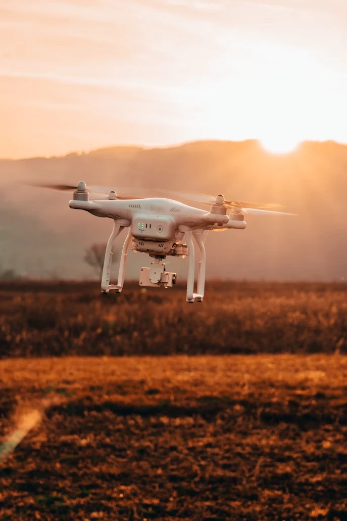
Forward-thinking insurers are using the IoT to innovate in their field. The use of smartphone and tablet applications and cloud-enabled technology (and the integration with other technologies) has helped face down these challenges thanks to Technorely for seamless work- but perhaps the most exciting development of all is the use of unmanned aerial vehicles (UAVs), otherwise known as ‘drones’ by Skyglyph.
According to a report by Deloitte, an incredible 2.85 million small drones could fill our skies by 2022. It’s expected that around 450,000 of these drones will be used for commercial purposes. Applications are likely to include:
Firefighting;
Search-and-rescue;
Aerial surveying;
Crop monitoring;
Construction site management;
Film-making.
The projected value for drone solutions could hit $100 billion across all sectors by 2020, with $13 billion coming from commercial businesses. And presently, the insurance industry makes up a healthy 17% of commercial drone usage.
Perhaps one of the most exciting things about using drones in the insurance industry is that they can impact every aspect of the insurance value chain. For instance:
Pricing accuracy and risk reduction – Assessing a site from the sky allows for a more accurate risk profile, which in turn impacts the costs involved.
Monitoring natural disasters – Drones can also be deployed to safely and quickly monitor areas under threat from natural disasters, such as fire, drought, flood, and earthquakes.
Site inspection – Using drones offers a faster, safer, and more cost-effective way to undertake site inspections and measure damaged areas – especially if doing so from the ground compromises the safety of the inspection team.
Claim decisions – The decision-making process is made a great deal easier thanks to precise and high-quality imagery.
Fraud prevention – Fraudulent claims amount to $32 billion each year. Drones can help counter these claims by capturing accurate information in a timely manner.
The introduction of drones into the insurance industry will also impact three important areas: risk management; claims management; and direct and indirect employment.
Drones will help risk management become more proactive and predictive. They can help identify and quantify risks and can do so faster and more safely. This approach will also keep field workers from exposure to radiation or toxic gases, and will spare them from working at height, or in challenging conditions. Ultimately, using drones for aerial surveying could help lower work-related injuries and fatalities.
Likewise, the claim management process will be greatly improved for every stakeholder. The claim adjuster will be in a position to process more claims thanks to express access to more accurate information, while the customer will have confidence that their claim will be addressed quickly. And the insurer will see significant savings thanks to an altogether more efficient workflow.
While the improved and efficient workflow mentioned above might result in fewer jobs within the insurance industry, the fact is more specialist roles will be created. Drones will need to be manufactured, maintained, and piloted. And the data the drones collect needs to be processed, stored, and analyzed.
By implementing drone technology, the insurance industry could, directly and indirectly, create new jobs – something backed by the Association for Unmanned Vehicle Systems International, which predicts over 100,000 new jobs by 2025 in the US alone due to the growth of the drone industry.
This incredible economic potential has opened the door for a number of innovative companies – none more so than our client, Skyglyph.

Skyglyph sits at the cutting edge of the aerial survey space, delivering solutions designed to bridge the gap between drone technologies and end-user requirements.
Its cloud-based platform helps to simplify both the scouting process and the management of flight control, resulting in better asset mapping, site monitoring, data transfer, and visual result interpretation. For the agri insurance industry, Skyglyph delivers an end-to-end solution to streamline the claim process and offer insights and benefits to both the farmer and the insurer.
When a farmer makes a crop damage claim, the insurance company needs to examine the scale and legitimacy of the damage. Undertaking such an assessment on the ground can take around 5 days, and sometimes even longer, depending on the size of the crop. However, with the help of drone technology, this can be reduced to several hours.
The process involves three applications, each used at a different stage of the claim assessment process. Technorely was involved in the development of all three.
The Aero Scouter. This is the mobile app that helps operate the DJI drone missions. These missions collect vitally important aerial imagery. The app simplifies the entire process so that even someone unfamiliar with drone operation can undertake the assessment. Mission parameters are uploaded to AeroScouter in advance, meaning the users only need to unpack the drone and push start. The mission is then fulfilled without any further human intervention.
The Ground Scouter. This app helps to prepare the aerial missions, automatically syncing any data collected with the web platform.
Report Viewer. Finally, if an audit is required, the Report Viewer app provides the auditor with the necessary information collected by the drone, in addition to other important data. The app is available offline, further assisting the auditor when working in an area with limited or no internet connectivity.
Everything is then uploaded by the drone to the Skyglyph server. All photos are merged together to provide the full picture of the field. The map is then used by insurers to study the field in detail and make a decision on the extent of the damage.
We took over the project at the initial stage of development and applied an agile approach to the development of the Web and Apps and executed the project within the estimated time frame satisfying our client’s demands.
The Skyglyph project was a Fixed price model and completed using the following technologies and expertise.
Technologies used: Scala, Play Framework, Activator, Akka, Slick, Casbah, SecureSocial, Spark, AngularJS, Bootstrap, OpenLayers, Geoserver, Postgres, MongoDB, Jelastic, Heroku, AWS, AWS S3, Elastic Map Reduce, SBT.
Web Team composition: One front-end and one back-end developer.
Mobile Team composition: Two android mobile developers.
The partnership between Skyglyph and Technorely produced the following results:
Improved and accurate pricing;
Reduction of risk;
6x faster claim processing;
30% decrease in loss payouts;
30% reduction in survey costs.
And the cherry on the cake came when Skyglyph was recognized with the StartUp InsurTech Award at the Digital Insurer Awards. This was thanks to their dedication to the digitization of crop insurance, the overall efficiency of the solution, and the prospect of further work in this area.
With the ever-growing demand for Skyglyph services in Poland, German and other European countries, Insurance companies have started adopting this innovative technology to enhance their productivity.
From performing the scouting process and managing flight control, to asset mapping, site monitoring, data transfer, and result interpretation, we’ve worked closely with Skyglyph to deliver an award-winning, game-changing technology.
And we can do the same for you! If you have a cloud-enabled drone app idea, get in touch today to discuss it with our team.